September 5 - 7, 2015
Saturday was my birthday and the thing I most wanted for my
birthday was to be traveling again. I
wanted to get out of town early but, as my camera had been possessed by demons
at the Alta Vista Petroglyphs back in February, I needed to buy a new one before
I set off. The Best Buy in Walnut Creek
was very helpful in helping me choose a camera, but they did not have the one I
selected. The Dublin store was on my
way. I had to make another stop there to
purchase the Nikon P610 that had most of the features I desired (60x optical
zoom, viewfinder, and WiFi connectivity) without being prohibitively
expensive. I like a good camera, but my
travels are hard on them, so I don’t like to spend a whole lot. This one would allow me to upload photos to
my phone and thence to Facebook, which was handy.
 |
| Marina del Rey |
By noon, I was on the road and headed to LA. I arrived in Marina del Rey at 5:30 and just
had time to get settled on my friend Michelle’s boat before heading off to meet
my old friend, Joe, for dinner at Killer Shrimp, my favorite restaurant. Michelle had been occupied on a sailboat race
until late, so Joe and I had a leisurely dinner and caught up until she got
home around 11:00.
Sunday, I went for a sail on my friend John’s boat with a
big group of friends who had assembled for my birthday. It was wonderful to see everyone and I felt
very popular. The South Coast Corinthian
Yacht Club just happened to be having a party with a live band that evening,
which I co opted for my birthday party, since Michelle had asked me to invite my
friends because she wanted it to be well attended. Several more friends joined us for the party,
as well as my cousin Ronda. My friend,
Tom, even baked a cake. It was a great
success.
 |
| Sailing on Out to Play |
Having been a bit worse for wear after the Dark and Stormies
at Killer Shrimp, I had not been up to a long run on Sunday morning. Monday, I was out of excuses. I got up early and ran from Marina del Rey
pretty much all the way to Manhattan Beach and back along the bike path. I had been training for a half marathon
coming up in October and I finally managed to run the whole distance that
morning. I was tired and sore, but proud
of myself. After spending a nice morning
with Michelle and her boyfriend, Alex, I hopped in my car and drove straight to
Las Vegas.
By the time I reached Las Vegas, I was too tired and sore to
even think about gambling or shows. I
stayed at the Excalibur. Unfortunately,
the hot tub closed before I got there, because I could have used a soak. As it was, I got some dinner and retired to
my room.
 |
| The Excalibur |
September 8, 2015
I got up early, ate some breakfast, and pulled out of Las
Vegas just after nine in the morning. I
drove north on I-15 through Nevada and across a corner of Arizona to St. George
Utah. Nevada was desolate, but Arizona
was a little greener and Utah seemed positively verdant by comparison. The road climbed upward as I drove north
through Utah, reaching nearly 8,000 feet in places. It seemed strange to see farmers irrigating
hay fields after the drought in California, but the sky was filled with thunder
clouds and I could see rain in the distance.
I continued north on I-15 to Utah 20 and then cut across the mountains
to Utah 89, which I took to Panguitch.
 |
| Utah Was Green |
 |
| Red Rock Canyon |
 |
| Highway 12 Scenery |
I
stopped in Panguitch for lunch, gas and grocery shopping. I stocked up on food, ice and propane for
camping and then continued up the highway to Utah 12. Highway 12 is the route to most of the
National Parks in Utah and is very scenic.
I stopped several times to take
pictures in the Red Rock area near Bryce and again to take pictures of Capitol
Reef. Just before they closed at 4:30, I
ducked in to the Esclante Grand Staircase Visitor Center in Cannonville where I
picked up a map and some advice on hiking.
 |
| Escalante Petrified Forest State Park Campground |
I wanted to get to my campsite before dark, so I passed on
the hikes near Cannonville and headed straight for Escalante Petrified Forest
State Park where I had a campsite reserved.
I got there in plenty of time to pitch my tent and blow up my air
mattress and still get in a hike through the petrified forest before dark. The main loop is about a mile up onto the top
of the mesa and back. An additional
three quarter mile loop drops steeply down the other side of the mesa before
returning to the top. It is a bit of a
scramble, but worth it because the majority of the petrified wood is found
there. The trees were buried in mud and
silt and the wood was gradually replaced with minerals over millennia. The petrified logs are scattered about and still
look amazingly loglike, despite being composed of colorful stone.
 |
| Petrified Wood |
I got back to my campsite well before dark. The campground was a pleasant surprise. It was much more attractive than it had
appeared on the website. There were nice
restrooms and showers and even a lighted dish washing station. Even WiFi was available. I cooked a dinner of steak and beans and
munched on raw carrots. After dinner, I
sat in my tent to avoid mosquitoes and worked on my blog until bedtime.
 |
| Petrified Log |
September 9, 2015
 |
| Pictographs in Lower Calf Creek |
 |
| Desert Varnish |
The town of Escalante was named after Father Escalante, but
“escalante” means "stepped up" so the name is perfectly suited to the region of
stair stepped mesas. I had a big day
ahead of me and didn’t get up as early as I had planned. I managed to leave the campground by 8:20,
but it took me 45 minutes to drive to the Lower Calf Creek trailhead. The trailhead was inside the Calf Creek
Recreation Area, which had a pleasant campground, although no showers. I took the three mile hike up to Calf Creek
Falls. It was uphill, but not steeply so
and would have been quick if it weren’t for the deep sand in many places. The trail followed the creek. Along the way were pictographs and other
evidence of the Fremont civilization.
I’m sure they didn’t call themselves that but, since they had decamped
by the time white folks arrived, we had to call them something. The scenery was impressive with lots of red
rock formations and some impressive desert varnish, a blackish or rusty stain
on the rocks caused by microorganisms fixing the minerals found in water
running off the rocks. Scientists
believe that it is likely that similar organisms could be found on Mars. I didn’t feel like I was on another planet,
but I did feel like I was in Disneyland at times because the rocks were so
fantastic.

 |
| Lower Calf Creek Falls |
It took me an hour and a half to get up to the falls, since
I kept stop-ping to take pic-tures and read my trail guide. The falls were gorgeous and there was an
inviting pool at the base that would have been great for a swim if I had had
the time. Instead, I took some photos
and marched back down the trail, returning in just an hour.

 |
| Grosvenor Arch |

My next stop was the Grosvenor Arch, which was at the end of
a road intersecting the highway at Cannonville.
I stopped in the town of Escalante and bought four gallons of water,
since the five gallon jug I had brought turned out to be leaky when I tried to
fill it earlier in the day. Cannonville
was nearly an hour from Lower Calf Creek and the arch was 19 miles from
Cannonville. The first nine miles were
paved, but the last ten miles were dirt.
The road wasn’t bad, but there were some steep hills and one stream
crossing that would have been ugly after a rain. The Mini made it just fine. I was the only person at Grosvenor Arch,
which was kind of amazing, since it is the signature feature of Grand Staircase
– Escalante National Monument. From
there, the road continued another thirty miles to highway 89. Unfortunately, that stretch was closed. I say unfortunately because the park is
immense and I had to drive over 200 miles to reach the spot where that road
intersected highway 89.
 |
| Dirt Road to Grosvenor Arch |
 |
| Glen Canyon Dam Visitor Center |
It was 3:00 by the time I made it back to Cannonville from
Grosvenor Arch. I retraced my path along
Highway 12 to Highway 89. I drove south
on Highway 89 and then followed it east along the border with Arizona. I drove and drove and drove and still I was
in the Grand Staircase Escalante National Monument. Finally, I reached the border of Arizona and
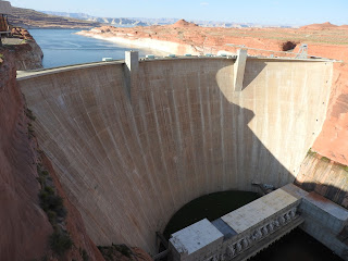
passed into the Glen Canyon National Recreation Area. I stopped
briefly at the Glen Canyon Dam Visitor Center and then drove like mad
down Highway 89 and into the Navajo reservation. My goal for the evening was the Hopi Cultural
center on Second Mesa and I wanted to make camp before dark.
 |
| Glen Canyon Dam |
 |
| Bridge Over the Colorado River |
 |
| Road Through the Hopi Reservation |
The Hopi reservation is an island in the center of the
Navajo reservation. The sun was setting and
I needed gas. Unfortunately, the Hopi
reservation was distinctly third world and there were no gas stations in
sight. I started to worry that I was
going to run out of gas. Finally, just
as the sun set, I pulled into the Hopi Cultural Center. The Cultural Center has a motel and
restaurant. It would be an exaggeration
to say that there was a camp ground, but there was an empty lot with tracks
between juniper trees where one could camp for free. The employees at the Cultural Center were
very welcoming and allowed campers to
use the restrooms at any hour of the night or day. I pitched my tent in the dark and cooked my
dinner. Oddly, despite the primitive
conditions, I still had a data connection.
It seemed out of place to be lying in my sleeping bag and uploading
photos to Facebook.


 My next stop was the Grosvenor Arch, which was at the end of
a road intersecting the highway at Cannonville.
I stopped in the town of Escalante and bought four gallons of water,
since the five gallon jug I had brought turned out to be leaky when I tried to
fill it earlier in the day. Cannonville
was nearly an hour from Lower Calf Creek and the arch was 19 miles from
Cannonville. The first nine miles were
paved, but the last ten miles were dirt.
The road wasn’t bad, but there were some steep hills and one stream
crossing that would have been ugly after a rain. The Mini made it just fine. I was the only person at Grosvenor Arch,
which was kind of amazing, since it is the signature feature of Grand Staircase
– Escalante National Monument. From
there, the road continued another thirty miles to highway 89. Unfortunately, that stretch was closed. I say unfortunately because the park is
immense and I had to drive over 200 miles to reach the spot where that road
intersected highway 89.
My next stop was the Grosvenor Arch, which was at the end of
a road intersecting the highway at Cannonville.
I stopped in the town of Escalante and bought four gallons of water,
since the five gallon jug I had brought turned out to be leaky when I tried to
fill it earlier in the day. Cannonville
was nearly an hour from Lower Calf Creek and the arch was 19 miles from
Cannonville. The first nine miles were
paved, but the last ten miles were dirt.
The road wasn’t bad, but there were some steep hills and one stream
crossing that would have been ugly after a rain. The Mini made it just fine. I was the only person at Grosvenor Arch,
which was kind of amazing, since it is the signature feature of Grand Staircase
– Escalante National Monument. From
there, the road continued another thirty miles to highway 89. Unfortunately, that stretch was closed. I say unfortunately because the park is
immense and I had to drive over 200 miles to reach the spot where that road
intersected highway 89.


No comments:
Post a Comment